 |
|
|
|
|
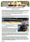
Barmby Moor enclosure 1783
and landowners/occupiers in the
mid-1800s
|
|
This complex map was created by John Nottingham, with the assistance of Mike Silburn, to show the situation within the Barmby Moor parish at various stages of its history from the late-1700s to the early 1900s. The following events are depicted: - The parish boundary (the continuous yellow line) was as at 1783; noting that, in those days, the boundary extended east along Barmby Road as far as Tayleure Terrace, and along West Green, but excluded the original (1514) Pocklington School buildings. - The 'Close' (field) boundaries as allotted in the 1783 enclosure act (dashed yellow lines); with the allotment holders and field acreages being listed in the table. - For assessment of tithes, the then Landowners' names are also listed in the table, with the names of the occupiers/tenants. In some cases, the original enclosure fields had been sub-divided, with both landowners being named. The source documents for this information are undated but are thought most likely to have been in the mid-1800s. - The boundary of the Barmby Grange Farm in Hodsow Field, as at 1839, and incorporating several enclosure closes (magenta line). - The 1847 York to Market Weighton railway running through the Barmby Moor and Pocklington parishes (grey line). - The enclosure closes purchased on behalf of Pocklington School by the then Headmaster, Dr Frederick Gruggen, as at 1862 (blue lines), some boundaries being constrained by the railway. (Some other purchased lands were in the Pocklington parish and elsewhere.) - The change to the Pocklington/Barmby Moor parish boundary in 1901 when some 50 acres of the Barmby Moor parish were transferred to Pocklington (primarily lands west of Tayleure Terrace, including Wilberforce Lodge, Dolman House, St. John's Lodge and much of the present Pocklington School playing fields).
The assistance of the "Treasure House" at Beverley in providing some source information is gratefully acknowledged.
To view the full-scale map, please click on the 'View fullscreen' link. Then scroll down to see the Close numbers with their acreages, the Landowners and Occupiers' names, etc.
|
|
|
|